Keats High Points
Wednesday, November 29, 2006
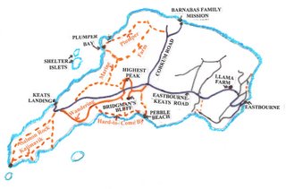
Keats Island is one of the undiscovered delights of the islands of the Salish Sea. It has many trails, most of them private, but the landowners are happy for you to use them responsibly. Today was a gray day, but visibllity was good so we decided to walk over the two high viewpoints - Bridgman's Bluff and Highest Peak.
 We caught the 9:20 ferry from Horseshoe Bay to Langdale where we changed onto BC Ferries' Stornaway passenger vessel which first stops at Gambier Island. On this leg of the journey we met Wolf Wiedermann who gave us a copy of a new map of the Gambier Island trails. He gave us a brief description of the state of each trail and how to find the start of those that were difficult to find. The final leg took us to Eastbourne on Keats Island.
We walked up the hill and made our first traditional stop to say hello to the llamas. The females were in the meadow and scooted up to see us. Each male was in his own enclosure. We carried on along the road to power pole #40 where the road leads off right to Barnabas Family Missions. However, we took the dirt road leading off left leading down to the old Presbyterian Camp and Pebble Beach. 
A short distance down, the road bends left and a sign says Walkers Welcome. Here we forked right and followed a track that used to be the old main road. It led up the hill through the trees and at the top of the hill the track led out to the main road. However, we went left back into the trees and at the high point veered left on a trail through the salal and followed it over fallen trees and continuing down until we finally reached Bridgman's Bluff, marked now by the remaining rocks of a fallen cairn. This was our well-earned lunch spot.
Making our way back to the road after lunch, we carried straight across the road at power pole #38 and took the rrail opposite, bearing left when we were a little way in to carry us round a knob of land on our right. We went briefly down a hill before curving left through salal and heading up a hillside. At the top, a trail carries on back down to the road but we bore left and were soon at Highest Peak. The official name for this point is Stony Peak but almost no one calls it that. Some signs call it Lookout Peak but that does not seem to be used locally. Highest Peak, although inaccurate, gets its name from being the peak near the highest point of the main road. This was our tea break.
After going briefly lower to a shelf offering views across to Gibsons, we retraced our steps to our point of entry and took the other trail down, emerging on the main road at power pole #35. We crossed the road and picked up a trail leading quickly to the orange-markered Winding Trail. This can be running water in the winter but today it was in good shape. We followed it down, checking for an orange marker where there was any difficulty, and came out to Gus Lund Road at the bottom. Turning left, we continued straight on until we reached a private house at the road's end. Here we diverged right following a Trail sign which brought us through long grass to Dr. Wicks' house - Peggy's Cove. It was 2:50 and he had told me that he left for the ferry at 3 o'clock and that we should call in and see him when we were passing. We went in, saw he was there and knocked. He was just preparing to leave but invited us to look at his eucalyptus and palm trees while he gathered things up.
 We made our way from his house (the last one in Keats Camp lands) through the camp and down to the ferry for the 3:25 departure. Dr. Wicks came later with bay leaves for the crew and one stem for us. On board he showed me pictures of an Open House held at his Bowen Island property as well as a family party at his North Vancouver home.
Return to Further Walks.
Archives
![]()